[ad_1]

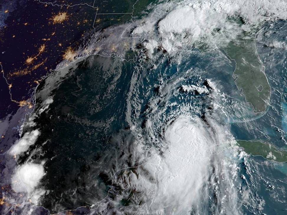
Hurricane Laura formed early Tuesday morning, as the storm’s center crossed into the Gulf of Mexico. Laura is forecast to make landfall along the Gulf Coast as a Category 3 storm.
NOAA/NESDIS/STAR GOES-East
hide caption
toggle caption
NOAA/NESDIS/STAR GOES-East

Hurricane Laura formed early Tuesday morning, as the storm’s center crossed into the Gulf of Mexico. Laura is forecast to make landfall along the Gulf Coast as a Category 3 storm.
NOAA/NESDIS/STAR GOES-East
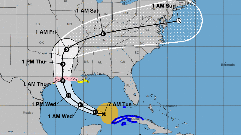
Hurricane Laura will make landfall as a major hurricane, with winds of around 115 mph and a storm surge up to 11 feet, when it strikes near the Louisiana-Texas border late Wednesday or early Thursday, according to the National Hurricane Center.
Laura was declared a hurricane Tuesday morning, when a NOAA hurricane hunter aircraft detected maximum sustained winds of 75 mph as the storm’s center was crossing into the Gulf of Mexico. It’s expected to draw more power from the gulf’s warm waters.
“Significant strengthening is forecast during the next 48 hours,” NHC forecaster Eric Blake said in his morning advisory.
A hurricane watch is now in effect from San Luis Pass, Texas, to west of Morgan City, La. Such alerts normally go out roughly 48 hours before tropical-storm-force winds could arrive.
The storm is moving west-northwest at nearly 17 mph – and forecasters say its long westward trip across the Gulf will give it time to strengthen.
When the storm arrives, the affected area could be large: Laura is projecting tropical-storm-force winds for 175 miles from its center, and it will bring huge amounts of rain to inland areas.

Hurricane Laura will gain strength as it crosses the Gulf of Mexico and will be a major hurricane when it makes landfall — likely near the Texas-Louisiana border, forecasters say.
National Weather Service
hide caption
toggle caption
National Weather Service

Hurricane Laura will gain strength as it crosses the Gulf of Mexico and will be a major hurricane when it makes landfall — likely near the Texas-Louisiana border, forecasters say.
National Weather Service
“There is a risk of life-threatening storm surge from San Luis Pass, Texas, to Ocean Springs, Mississippi, within the next 48 hours,” the NHC says, describing a a storm surge watch that is now in effect.
Category 3 storms like Laura is expected to become routinely cause “devastating damage” to homes, trees and infrastructure, according to the National Weather Service. Recent Category 3 storms include Harvey, which hit Texas in 2017, and Rita, which hit Louisiana in 2005.
Laura is predicted to remain a tropical storm for at least a day after making landfall, bringing intense rainfall.
“The threat of widespread flash and urban flooding, along with small streams overflowing their banks, will be increasing Wednesday night into Thursday from far eastern Texas, across Louisiana, and Arkansas,” the NHC says.
Over the weekend, Laura’s remnants are predicted to spread rains into the middle-Mississippi, lower Ohio and Tennessee Valleys.
[ad_2]
Source link